


You can drive for 10 hours and 30 minutes and still be in Germany.
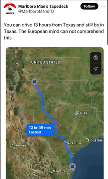
Let’s not talk driving hours, let us talk mileage. 13 hours on a Texas highway is going to cover much more land than trying to drive some 12th century side street in an Italian village at 5km/h.
It was crazy to realize on a recent road trip through the middle of the US, that half of my day’s planned drive was the width of Germany.
My european mind doesn’t give a shit about the us , it doesn’t even think of it .
I know lots of euro bros are showing how long their country is, but I think the point is that Texas is a state, not country. When you compare those things it’s quite impressive, however still not even the largest state in the world. Here are some others. A nice drive from Anchorage to Prudhoe Bay will cost you 17 hours, or in Amazonas, Brazil, Manaus to Cruzeiro do Sul is 33 hours.
To the guy who annexed Arizona into California in order to beat Texas, shame.
On the other hand, when you start from Texline (which I suppose is the starting point of that 13 hour journey) in the northeast of the state, you could easily escape Texas within minutes.
On the other hand, in Europe you can get through a number of countries in thirteen hours just because we have a working road system.
deleted by creator
Let’s just say that when crossing the Pyrenees you don’t want to stray from the main north-south(ish) roads…
European here (Brit). I could drive for 13 hours along the M60 and still be on the M60. No problem comprehending that.
Finland: 17 hours from Utsjoki to Helsinki.
Norway: 36 hours from Vardø to Lindsenes.
Sweden: idk why you’d go thereFor beer
Wtf I can’t even name a single Swedish beer
Haha, that’s probably one of the last things to go Sweden, unless you like that 2.1% ultralight barely beer passable tank washing water
I can’t even comprehend this comment. Swedes leave the country for beer.
Ok but western Australia has everybody here beat

Well there’s a European country where you need a week long train trip from one part of it to the other.
Americans don’t really care about how big AUS is, we just can’t figure out how your wildlife is as deadly as our high school students
It’s mostly the emus that you need to watch out for… Just ask our army
Is there a secret emu army? Ready to repel all potential land invaders somehow crazy enough to attempt Australia?
The American mind cannot comprehend this!
How long is the drive from Nome to Juneau?
I just punched it into my GPS to find out and it came back with results for plane tickets lol, I didn’t even know my GPS app could do that
Gotta watch out for that one speed camera
I was coming in with this cause it’s straighter haha.
Then see you WA post.
I’ve done both of these trips before too and them some to get where I’m actually going
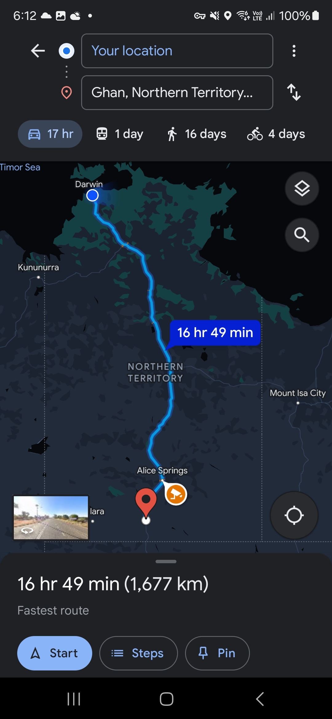
I haven’t done the WA one but I’ve done Adelaide to Darwin which was a very barron but beautiful drive, would love to do the WA trip one day
Sounds like the perfect place to go for a drive and listen to the Left Right game.
It’s only 1hr longer than Tweed Heads to Cape York in QLD
True. Everyone there lives on the southeast side, though.
The world bows to Australia
deleted by creator
deleted by creator
Yeah, well, I can drive 1 hour and cross 3 borders. And I won’t have to go through an immigration/customs checkpoint at any of these borders.
Now someone reverse it for me, what’s the MOST amount of countries you can drive through in 13 hours?
In North America, we think 100 years is a long time. In Europe they think 100 miles is a long distance.
deleted by creator
23 hours is about as high as you are going to get while maintaining a (relatively) straight path. The north is not really accessible by road.
Edit: I take that back. I managed to get up to 27 hours driving from the Ambassador Bridge to Windigo Lake.
IMO the USA doesn’t have that much “space” it just takes awhile to cross. Land utilization is fairly high and much of unused lands needs constant conservation efforts to maintain wildlife.
Some people in Daytona Beach can drive 500 miles without even leaving the stadium.


